| Home Topics Memorials Miscellany Transcripts References Family History Glossary Latest Beeston Blog About us | Site Search |
|
The Origins of the Placenames and Fieldnames of Beeston - by Ivan MorrellAcrelands Meadow and Closes - These closes, which were sited on the northern side of the canal stretching from the present canal bridge to Trent Road, were documented in the 14th Century as the Le Akilandole. The names derive from O.E. Æcer, land, Mædwe and O.F. Clos, with Akilandole influenced by O.Scand Akr, both the English and Scandinavian forms meant strips of cultivated land. Alsweteland - Documented in 1333, the second and third elements of the name derive from O.E. Hwæte and Land, land where wheat was grown, possibly locating it in the Wheatlands of the Nether Field. The first element of the name may refer to the Alsow family who were documented holding land in Beeston during the 14th Century. Ample / Imple Dole - Various parcels of land with this name were sited in the Common Meadow between the canal and the Trent, as well as in the Church Field. The name Ample/Imple has been thought to derive from O.E. Impe meaning a grafted sapling. However, the same 18th Century documents mention other words that denote size i.e. Mickle Dole and Muckle Dole, so it is reasonable to assume that, in these cases, Ample had the meaning of adequate or standard sized. Dole derives from O.E. Dāl meaning a share or portion of the field. Ash Furlong / Ash Close - There were two adjacent Ash Furlongs in Beeston, one in Tuttle Bridge Field and the other in Far Field, both in the general area of the present Farfield and Wallett Avenues. Prior to the enclosure and the creation of the Far Field in 1612, the two Ash Furlongs would have been one furlong. Ash Close, mentioned on the 1863 Middleton Estate Map, was in the area of the present Boundary Road, and extended to the close known earlier as Short Whitebutt in the area of the present Brook Road. Named from the Ash trees that grew in this area, the name derives from O.E. Æsc and Furlang. Astortlands at Longlands - Documented in 1341, this was one of the Longlands group of closes in the Nether Field. The name, which derives from O.F. Assart, meant land cleared from woodland not yet brought into arable use. Later documents refer to woodland in the Longlands, presumably remnants of the woodland from which the Assartlands were cleared. Barn Close - Situated in the Nether Field in the area that is now the southwestern part of the Siemens site. Previously it was thought that Barn Close may have been the earlier Stone House Close mentioned in a 1603 will, but this is more than likely Stonehouse Meadow in Lenton Parish that abutted onto the Hassocks, [see Stonehouse Hay Sick Close]. The name barn derives from O.E. Bere + ærn which originally meant a barley store. Beeston Stoopes - The name is known from the 1575 bounds of Lenton. From the other names written in the bounds the actual place can be located near to the banks of the Trent in the Common Meadow on the Lenton/Beeston boundary. The name, which derives from either O.E. Stūpian or O.Scand Staup, modern stoop, also had the meaning "to slope down". Some feature must have been really prominent at one time to have given rise to this name. The present contour of the riverbank does fall away slightly towards Beeston at this point but not markedly so. Whatever the feature was, it would have been long since destroyed by the ploughing of the land and the dredging of the river here. It was near to this boundary point, during dredging work on the river in the 1938, that Bronze Age settlement remains were discovered along with dug-out canoes, bronze weapons, skulls, and a later 6th Century Anglo-Saxon shield boss and cruciform broach, denoting a Anglo-Saxon burial at this point. It is tempting to think that the skulls may once have been covered by some kind of mound which was later re-used in the 6th or 7th Century for a burial and territorial marker by our Anglo-Saxon ancestors. Beeston Windmill - Beeston's windmill is thought to have been situated in the Church Field, in the general area of Beeston Fields Drive and Old Drive, where there was a Mill Close documented in 1809. Black Mould Nook - This small close, the name of which denotes it was a damp corner, was situated in the Church Field in the area of Bramcote Drive West and Charnwood Avenue. The name derives from O.E. Blæc, Molde and M.E. Nook. Where the word black occurs in fieldnames, it usually denotes fertile land which, in some instances, points to previous habitation. Blotoff or Blotah Dyke, Bloty Pool - The route of the present Beeston Canal from Dunkirk to Beeston Weir follows the course of the old Blotoff or Blotah Dike. Bloty Pool would have been located somewhere along its course in Beeston, probably in the area between the present canal bridge and Beeston Lock.. Part of this dike near to the old Beeston and Lenton parish boundary was known as the Littling Ditch, named from a Lenton field called Littling Meadow.The dike takes its name from either O.E. Blāw or M.E. Blo meaning bleak or exposed, O.E. Tōh meaning tough or sticky in this case muddy and O.Scand Dyke. The dike's course in Dunkirk originally ran through land considered as moorland, part of which was called the "Bull Mires" and "The Great Miry Close" giving rise to the bleak and muddy name of Blotah Dyke. An earlier name for the Bloty Pool was probably the Lynpol mentioned in a 1316 document. Borke or Burke Doals Furlong - It was recorded on a 1601 Terrier and, from the documents intinerary, it is probable that Burke Doals Furlong may have been an earlier name for the small Broad Gate Close in the Tuttle Bridge Field. This furlong was situated just to the west of the present Salthouse Lane off Broadgate. The name probably derives from the families of Geffrey and Christofre Burke documented holding lands in neighbouring Chilwell in 1575. The surname itself can derive from either O.Scand Birk or O.E. Birce, meaning a Birch tree. The name Burk is a known northern form of Birch. The remainder of the name derives from O.E. Dāl and Furlang, meaning a portion or share of the said furlong. Bostock's Headland Furlong - Situated in the Far Field, in the area of the western end of the present Middleton Cresent on the northern side of Derby Road. The headlands which are often called heads or hades in 17th Century documents, were strips of land left at the ends of the furrows enabling the ploughteams to turn. The term derives from O.E. Hēafodlond and Furlang, while the name Bostock refers to the family of Leonard Bostock mentioned in a 1610 document. Bradoe - The name is known from a 1611 Terrier deriving from O.E. Brād and Hoh, meaning a broad hill-spur or heel of land. A group of 12 closes in Chilwell with the associated name of Braddow Leys are mentioned on the 1845 Chilwell Tithe Map and Award. These were situated just to the north and south of the present railway line where the tracks meet the Chilwell / Beeston parish boundary. Bradoe then appears, from the other lands mentioned in the 1611 terrier and the associated names on the Chilwell Tithe Map, to be in the general area of the Gleadwong, Haverland Closes and the Heanings in the Nether Field. Bramcote Nook - Situated in the Far Field in the area of the present Windermere Road and Keswick Close on the southern side of Derby Road. The name derives from O.E. Brōm, Cot and M.E. Nook meaning the sheltered corner of land near to the cottages where broom grew. Briery - The name is self explanatory, the briar field being situated in the Tuttle Bridge Field in the general area of the northern half of the present Peveril Road, Carisbrooke Avenue, and the eastern half of Kenilworth Road. The name which derives from O.E. Brēr, was documented in the 14th Century as Les Brerrodes. Broadgate and Broadgate Close - Broadgate was part of the Nottingham to Sawley turnpike, and documented as early 1341 as Brodegate meaning the broad or wide road deriving from O.E. Brād and O.Scand. Gata. There were also fields that abutted onto the northern side of the High Road stretching from W.H.Smith's store to near Salthouse Lane, which were also called Broadgate. In this case, it is probable that the gate element of the name derives from M.E. Gate giving a meaning here of the broad pastures, a description which perfectly described the size of the fields here. Broadgate Close was the name of a small enclosure flanked by Salthouse Lane on the east and Broadgate on the south. Nether and Over Broadland - These two closes were situated in the Church Field, with Elm Avenue as their western side, Enfield Street as their north, a line including Vicarage Street for their south, and a line including Foster Avenue as their east. Listed on the 1601 Terrier as Broadlands furlong and Little Broadlands furlong, their northern and southern boundaries may suggest a previous association with the Gravel Pit and Middle Bush Closes on their eastern side which flanked onto Wollaton Road. The names derive from O.E. Niðera, Ofer, Brād and Land. Broadland here means broad strips. Brodeholdmor - Documented in 1341, the broad old moor can only refer to the Home Corner Closes and the Hassock Closes. As with le Oldemor, these two areas of closes were situated to the north and south of the present railway tracks. Further evidence of this moor field is found just a little further along the railway tracks at the deserted village of Morton whose name meant the farmstead in the moors. Morton's site is now marked where the railway tracks cross the Beeston to Nottingham Canal at Dunkirk. The name derives from O.E. Brad, Eald and Mor. Brook Close[s] - As their name implies, these closes were situated alongside the Tottle Brook in the Tuttle Bridge Field. Their position is now framed by Woodside Road on their east, on a line including Salthouse Lane on their west, Meriden Avenue on their north and the new University Complex on Broadgate on their south. On the 1863 Middleton Estate Map the same name was also applied to the nearest of the Comb Closes to Derby Road in the Far Field. The name derives from O.E. Brōc. Brook Furlong - This furlong lay in the Tuttle Bridge Field on the southern side of Broadgate between Humber Road on the west and a line between Albert Road and Woodside Road on the east. The furlong took its name from the West Hassock Drain which formed its southern boundary, and derives from O.E. Brōc and Furlang. Broomy Leys - Situated in the Far Field, Beeston Cemetry now occupies its site on the southern side of Hillside Road. The name derives from O.E. Brōm and O.E. Leah, meaning a broom covered clearing. A Brome Close was mentioned in the 1611 will of Edward Homes. Brown's Lane - This is the northmost section of Station Road, Brown's Lane originally only ran from the Turnpike Road [High Road] down to Nether Street, no road existed beyond this point, though ther may have been a trackway, [see Greengate]. The later 1901 O.S. map shows the modern extension of Brown Lane down to Queens Road named as Victoria Avenue, with only the short section from Queens Road down to the railway station known as Station Road. Six members of the Brown family, after whom the lane is probably named, fell victim to the 1593/94 plague, a Brown's Close was mentioned in the 1600 will of Edward Raven. Brunt Close - Thought to be in the area of the Barn and Trent Closes in the Nether Field. The name could have originated from one of two sources, either the land cleared by burning or the surname Brunt which itself is a variation of the surname Brent. Both of these two sources derive from O.E. Bryne or Brennan meaning burnt or to burn. Butcher's Lane - The southernmost section of the present Wollaton Road from The Square to Cross Street, this section has also been known as Gravel Pit Lane. The origin of the name is uncertain. The 1809 Enclosure Map shows almost no habitation here, so the name is probably not occupational. The only presently known person from Beeston with the surname of Butcher that could have given rise to the name is Robert Bucher, whose 1617 will is on record. Canalside - Constructed at the same time as the canal in 1796, the road which was then known as Ryelands Lane originally only ran from the lock to just west of the present Appleton Road. When the road was extended to the canal bridge in about 1809, the whole became known as Ryelands Road. The modern name derives from L. Canālis. Chapel Street - Chapel Street was named after the New Connexion Chapel that was first built there in 1805. The chapel may initially have been accessed just by a path as no road is shown on the 1809 Enclosure Map. Chapel Street, which ran from the area of the present Square to Middle Street between Styring Street and Station Road, no longer exists. It fell victim to the developer's axe when the new shopping precinct was built in the late 1960s. Cheetham's Field - Known from the 1863 Middleton Estate Map and created out of the old Setcop Cutts and the Nether and Over Meergate Furlongs, [see below]. The name derives from the family of Henry Cheetham and O.E. Feld. Church Lane - Shown on the 1809 Enclosure map, the course of this lane originally ran from Middle Street, between the present Manor Lodge and the new Scout building, through the grounds of the old Church Street School to opposite the entrance of the churchyard on Church Street. The lane may originally have been a private road to the church for the inhabitants of Beeston's Manor house which is opposite the Middle Street end of the lane. The name derives from O.E. Cirice and Lanu. Church Street - Amongst the oldest streets in Beeston, its name is self explanatory. Although no church is mentioned in the Domesday Book of 1086 for Beeston and there is no documentary evidence for one until the 12th Century, this does not necessarily mean there was not a church or place of worship of some form at Beeston prior to these dates. It must be remembered that the Domesday Book was a tax assessment document; if a church or its land did not generate any revenue there would have been no reason for its inclusion. Many Anglo-Saxon churches, that were both small and built of wood and thatch, would have left little if any archaeological record. There are many churches today where it is known from excavations that they were in being prior to the conquest of 1066, although they were absent from the Domesday Book of 1086. In Beeston's case it is perhaps significant that the old church compound may have included part of the area known as the Round Hill, as one of the Round Hill plot names on the 1809 Enclosure Award was situated where the Wilkinson's and Argos Stores now stand. If the Round Hill was an old burial mound of pre-history, the site may well have been a focal point not only for the early Anglo-Saxon burials of Beostune as was their custom, but for the early English Church also. The name derives from O.E. Cirice and Stræt. Church or West Field - One of the three open fields of Anglo-Saxon and Medieval Beeston, Church Field lay on the northern side of Beeston to the west of Wollaton Road. The names derive from O.E. Cirice, West and Feld. The City - This name which applies to the eastern end of Beeston's old village, has been thought to be one of the sites of Beeston's three Anglo-Saxon manors. The origin of the name "The City" is unknown, it may however be a colloquil name deriving from O.E. Cyte meaning a cottage, hut, cabin, cell or cubicle. In the 19th Century, The City was described as a street of small low thatched cottages built of stud and mud which were demolished in the early part of the 19th century. Clifton Close - Clifton Close which was situated in the general area of the present Leyton Cresent Recreational Ground was one of the Longlands group of closes in the Nether Field. The name probably derives from the fact the close had once been owned by the Clifton family.
Coal Cart Close and Coal Cart Way - Coal Cart Close was situated in the Far Field bounded by Derby Road on the north, Hillside Road on the south, Wollaton Road on the east and Windermere Road on the west. According to the 1601 Terrier the close was previously one of the Waterslake Closes. Coal Cart Way is thought to have been either another name for Sandy Lane or part of Middlegate which ran from Derby Road, opposite Sandy Lane, to the present Foster Avenue. The name probably derives from a route by which they transported coal from the early Wollaton and Strelley coal workings. The names derive from O.E. Col, O.Scand Kartr and O.E. Weg. Combs Closes, Combhole and Old Comb Nook - The Combs Closes were enclosed early in 1620 and Old Comb Nook in 1809. The Combs, which lay in the Far Field to the north of Derby Road and just to the west of the present Priory Island, included the southern end of Appledore Avenue. Old Comb Nook lay to the west of the present Middleton Cresent. Comb derives from O.E. Cumb meaning a hollow or a valley, often a hollow flank of a hillside. Combhole again would refer to this hollow. Nook had the meaning of a sheltered or secluded corner of land. Later 19th Century names for these closes include the Doctors and Parsons Combs, and the Near, Middle and Little Comb Closes. Common Baulk or Wong - The Common Baulk was situated in the Tuttle Bridge Field in the area of the present Warwick and Cedar Avenues. The baulks were unploughed areas between groups of strips which were used as boundary markers and in this case for communal grazing also. A "Wong", was originally a piece of unenclosed land in an open field system, the name later applying to just a meadow. The names derive from O.F. Commun, O.E. Balc and O.Scand.Vangr. Common Meadow - This was all of the land situated between the canal and the Trent, which would have been used for grazing and hay making.The western half was known as the Upper Meadow, the eastern half the Nether Meadow. The name derives from O.F. Commun and O.E. Mædwe. Common Pasture - Situated on the southern side of the old village, lying between the Townside Drain and Thorndike Drain, the pasture was originally an area of open land used for the communal grazing of animals. The name derives from O.F. Commun and L. Pastura. Constable Close - Documented in the 18th Century, the close was located in the Tuttle Bridge Field, near to the present day Central Avenue. The name derives from the Constable family who had lived in Beeston since at least the 16th Century. Cowgate Road - Now known as Wollaton Road, Cowgate Road ran from Gravel Pit Lane to Derby Road. Normally this name means that this was the road the cows went along to pasture, deriving from O.E. Cū and O.Scand Gata. However, there were two large furlongs on either side of Cowgate Road also called Cowgate. A cowgate was a term that originated in the 16th Century used to describe the amount of land required to graze one cow, or the right of pasturage for one cow. These two fields then could have been areas to pasture a set amount of cattle and named as such, and Cowgate Road was possibly named as the road to these cowgates. If so, the name would derive from O.E. Cū and M.E. Gate. On the 1863 Middleton Estate Map, the Cowgate in the Tuttle Bridge Field had been divided into Goss Close [see below], as well as Wilmot Close and Wilmot Field, that were named from the Wilmot family who had lived in Beeston from at least the 16th Century. Crabtree Field and Furlong - There is a heading on a 1601 Beeston Terrier, of Crabtree Field and East Field together. This suggests that at one time, there may have been four open fields, albeit temporary, before the Far Field was designated in 1612. Where Crabtree Field was situated is not known, other than the associated name of Crabtree Furlong. This furlong, from the itinerary for recording the 1601 Terrier, appears to have been situated somewhere near to the division of the later Far Field and Tuttle Bridge Field, possibly in the region of Central Avenue. Named from Crab Apple trees which grew there, and deriving from O.Scand. Skrabba and O.E. Treow. A furlong was nominally a 220 yard length of a ploughed furrow, deriving from O.E. Furlang. Crawcroft - Situated in the Church Field, and now part of Beeston Fields Golf Course on the Beeston / Bramcote parish boundary. The name derives from O.E. Crāwa and Croft meaning a small enclosure that was frequented by crows. Nether and Over Crawcroft Cutts - These two small fields which were situated in the Church Field to the east of the Crawcroft, are now also part of Beeston Fields Golf Course. Nether and Over mean lower and upper and denote their positions to one another. Cutts, which may be O.Scand either denotes that they were divisions of the larger Crawcroft, or refers to a water channel or drain. Crooked Dole - THe plot with this name, on a 1786 document, was situated somewhere in the Nether Meadow, perhaps in the area of the small paddock at the end of Cornwall Avenue, on the eastern side of the present canal bridge. Meaning the angled portion of land, the name derives from O.E. Crōcod and Dāl. Crookroods - The Crookroods were situated in the Tuttle Bridge Field near to the present junctions of Abbey Road with Warwick Avenue, Peveril Road with Hetley Road and Wensor Avenue. The name can either derive from O.E. Crōcod or O.Scand. Krokr meaning angled , and O.E. Rōd which was a land measurement of ¼ acre, the nominal area of each cultivated strip or selion. In this furlong, they would have been set on an angle due to the furlongs shape. Crosehowse - Documented in 1572, this is Cross House which would have been located near to the old village cross at the top of Dovecote Lane. The name derives from O.E. Cros and Hūs. There was also a later cottage known as Cross's House on Middle Street in the area opposite Union Street, which was named from the Cross family who lived there. Crosfurlong - Documented in 1337, the name is probably associated with Motteram Cross Gate, placing the furlong somewhere in the region of Sandy Lane and Far Hill in the Far Field. The name derives from O.E. Cros and Furlang. Cross Street - This street first appears between the 1809 enclosure and the 1841 Census. The name probably derives from the family of Thomas Cross who were documented holding lands throughout Beeston in the 18th Century. Crownrodes - As the name is only known from the 14th Century, this would denote land that had been held up to that time by the Crown, the Crownrodes were probably remnants of Peveril's estate that was confiscated by the crown in 1154. The name derives from O.F. Corone and O.E. Rōd. Its actual whereabouts is unknown. Danehowse - The name, which was documented in 1572, would have been located somewhere within the old village, though its actual whereabouts are unknown. This may have originally been Dena's house deriving from O.E. Dena and Hūs, Dena which is Old English for a Dane is also a recorded Old English personal name. Alternatively, the name may derive from the surname Dean, of which Dane is a known variant. Dead Man's Gardens - The land that was purchased in 1805 to build the Old Baptist Chapel on Nether Street was called Dead Man's Gardens. Names such as this normally develop from the fact that human remains at one time or another have been found there. Derbygate, Derby Strete, Derby Way - Previous names for Derby Road. Derbygate Hurst - This close was situated in the Far Field, with Derby Road as its southern boundary and the southern half of Sandy Lane as its western boundary. Hurst derives from O.E. Hyrst meaning a wooded hill or hillside. Derdene - Mentioned only in a 14th Century lease of John Burgeys, the name derives from O.E. Dēor meaning an animal, beast or deer, and either O.E. Denu meaning a valley or O.E. Denn meaning woodland pasture. Both the possible meanings of a valley or woodland pasture were possibly appropriate for the area of Derby Road.
Docky Lands - This close was situated in the Tuttle Bridge Field at the corner of Broadgate and Woodside Road where the new University complex has recently been built. The name derives from O.E. Docce and Land, the land infested with the Dock plant, although O.E. Docce also applied to the sorrel plant. Doddesholme - Doddesholme was the most easterly plot of land in Beeston, situated in the Hassock Closes on the western side of the present putting greens by Highfields lake. The name probably derived from the Dode family who were documented holding land in Beeston during the 14th Century, and either O.E. holm or O.Scand.Holmr meaning an island or a piece of slightly elevated drier ground amid marshy ground. Dovecote Lane, Dovecote Lane Close - According to the 1809 Enclosure Map, Dovecote Lane only ran from its junction with Market Street [Middle Street] down to the Heanings [Leslie Avenue]. Beyond this point from the Heanings to Middle Pasture Road [Queens Road] it was part of Meadow Road. On the 1901 O.S. map, the most southerly end of the present Dovecote Lane, from Queens Road to the railway, was known as Rylands Road. Beyond the railway, the lane continued as a footway on the course of the present Trent Road down to the canal. If this footway is projected beyond the canal, its course would have led it directly to the supposed site of the ford that crossed the river to Clifton. The lane was named after the dovecote that was associated with and stood near to the Manor House, probably near the corner of Dovecote Lane and Middle Street. Dovecote Lane Close lay between the Manor House and the Townside Drain on the eastern side of Dovecote Lane. The name derives from O.E. Dūfe and Cot and Lanu. Dobby Street - This name from a 1687 document is a known variation of the surname Dobb sometimes spelt Dobbe or Dobby, although it has also been suggested that the name could also have evolved locally from the surname Dalby. There is a record in 1773 of a John Johnson Dalby holding land in Beeston. The precise location of Dobby Street within the confines of the old village is not known. The favoured locations however are the West End, City Road or Middle Street. Dritdoles - Documented in 1337, the name derives from O.Scand Drit and O.E. Dāl and was probably the origin of Dirty Lane, [see above]. It may be contemporary with the plot in the Nether Field known as the Vicar's allotment. Drit had the meaning of dirt or excrement, so it is possible that the Dritdoles are Beeston's first known sewage disposal area, where the nightsoil men disposed of their loads. or - Click here to go back to the top |
|
||||||||||||||
|
|
||||||||||||||||
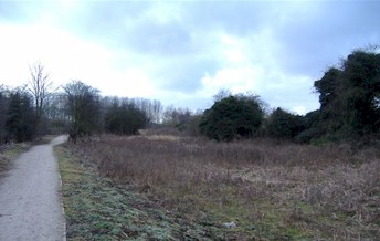 Clifton Orchard - On the 1809 Enclosure Map, this small area of land on the bend of the river below the weir and on the Beeston side of the river was actually
part of Clifton Parish. The hedgerow marking the northern boundary of this small area of land is still in situ (Shown left. The modern footpath follows the bend in the river; the hedgerow on
the right marks the northern limit of Clifton Orchard), and the gravelly beach here marks the site of a ford or ferry that
crossed the river between Beeston and Clifton. According to a late 18th century map of the Trent, showing proposed routes for canals, the land that was normally known as the
Common Meadow here was recorded as Clifton Upper and Nether Orchard. There is an old cut of the river here that can still be traced running from the present island in the river
diagonally across two fields to Beeston Lock. It is just possible that all the land to the south of this cut had originally belonged to Clifton which would explain the names
Clifton Upper and Nether Orchard. This area would then later be reduced to the smaller area on the 1809 Enclosure map after the cut had dried up. The name derives from O.E. Clif, Tūn
and O.E. Orceard/Ortgeard, which itself derives from O.E. Wyrt/Wort, a plant, + geard, a yard or enclosure.
Clifton Orchard - On the 1809 Enclosure Map, this small area of land on the bend of the river below the weir and on the Beeston side of the river was actually
part of Clifton Parish. The hedgerow marking the northern boundary of this small area of land is still in situ (Shown left. The modern footpath follows the bend in the river; the hedgerow on
the right marks the northern limit of Clifton Orchard), and the gravelly beach here marks the site of a ford or ferry that
crossed the river between Beeston and Clifton. According to a late 18th century map of the Trent, showing proposed routes for canals, the land that was normally known as the
Common Meadow here was recorded as Clifton Upper and Nether Orchard. There is an old cut of the river here that can still be traced running from the present island in the river
diagonally across two fields to Beeston Lock. It is just possible that all the land to the south of this cut had originally belonged to Clifton which would explain the names
Clifton Upper and Nether Orchard. This area would then later be reduced to the smaller area on the 1809 Enclosure map after the cut had dried up. The name derives from O.E. Clif, Tūn
and O.E. Orceard/Ortgeard, which itself derives from O.E. Wyrt/Wort, a plant, + geard, a yard or enclosure.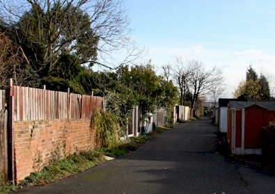 Dirty Lane - This lane (Shown left) which appears to be a continuation of Flitter Lane, was a private road to the vicar's allotments and to the Longland closes. Dirty Lane ran from Middle Pasture
Road [Queens Road], along the backs of the houses between the present Mona Street and Windsor Street, to the site of the vicar's allotment that lay near to the present railway tracks. A footway
then continued across the Thorndike Closes and along Longlands Drain to meet up with Musco-Sike Lane. The name Dirty Lane probably derived from the Dritdoles, [see below].
Dirty Lane - This lane (Shown left) which appears to be a continuation of Flitter Lane, was a private road to the vicar's allotments and to the Longland closes. Dirty Lane ran from Middle Pasture
Road [Queens Road], along the backs of the houses between the present Mona Street and Windsor Street, to the site of the vicar's allotment that lay near to the present railway tracks. A footway
then continued across the Thorndike Closes and along Longlands Drain to meet up with Musco-Sike Lane. The name Dirty Lane probably derived from the Dritdoles, [see below].